The trip home was to be, as the trip to Minnesota was. A long drive.
We had decided on the drive over that we wanted to stop in the Wisconsin Dells on the way back.
Edward had been there some 40 years ago and I'd never had the pleasure of experiencing the natural wonder.
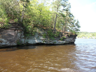
The Dells are natural sandstone carved out by the Wisconsin River as it makes it's way to join up with the mighty Mississippi.
 So a little more than 4 hours into our 11 hour drive, we pulled off the highway to have a look around. After a slight mix-up with directions and a quick hot dog from a stand at the side of the road, we found ourselves on a two hour river tour.
The cute young guide had clever names for several of the rock formations, but don't ask me to repeat them all. I was more interested in the formations than what they resembled.
But I believe there was a reference to a ship yard here.
I was fascinated with the angles of the rock.
I expected them to be parallel to the water. But that was not the case.
This is sandstone and these formations were made more from frozen glaciers than by running water.
The story goes that a natural dam formed in the glacier. Then when the pressure from the ice forced it to break, the entire Dells were formed in less than a month by the advancing ice.
And you think you're under pressure at work.
It's always amazing how much force can be behind water and ice.
I think there's a chimney rock in every state. Here is Wisconsin's.
And here we have the Indian Chief.
And speaking of the Indian Chief, a fun fact for those that have never noticed it. The Mississippi River divides Minnesota and Wisconsin. If you look closely, you can see that same Indian chief peering from Wisconsin into Minnesota at the Northwest corner of Wisconsin.
Something else you can see on this map is how crazy I am.
Look at how far I drove in one day!
Then turned around to do it again.
( Cause it was so much fun the first time )
More pictures tomorrow from where we got off the boat and explored the tight crevasses in the cliffs.


6 comments:
These photos are amazing. I love the Indian chief who's in the rock and on the map. That's so cool! I can remember years ago when I visited the White Mountains in New Hampshire we went to see an 'old man' who looks out over the country there. He looks a lot like your Indian chief!
Yes, very interesting rock formations....and all from sandstone! That was quite a drive Stew. Just think, the captain will be doing all the driving on your next excursion!!! Sit back and enjoy.
We tend to see faces in anything, don't we.
I believe the Old Man in New Hampshire is a granite cliff.
It's amazing that nature can do such things.
I'm not even driving to the airport!
(this is going to be different)
I'm glad you got a break from the long trip and saw the sights in Wisconsin. I never noticed that there was a Wisconsin Indian poking his nose into Minnesota! My granddaughter pointed out to me that when you look at the US map, Minnesota is the head-dress sitting on top of the Iowa head, Missouri and Arkansas are the pot belly and Louisiana is the feet of a figure separating the East and West. Like you said, we tend to see faces in everything!
I never noticed the Western Guard before. But now that you point him out, there he is! Odd looking fella, he is.
Here all this time I thought it was the Mississippi River that kept the East and West separated and instead, it's him.
Post a Comment